Wednesday, April 27, 2011

Mt. Hood- 45° 22' 24.21'' N 121° 41' 44.65'' W Elevation: 11233 ft


Located south east of Mt. St. Helens, Mt. Hood is the tallest mountain in Oregon. It was formed by the subduction zone, like Mt. St. Helens, and is also a stratovolcano in the Cascade Mountain Range.


Photo- http://www.fsl.orst.edu/wpg/research/hoodriver.htm

Cougar, Washington 46° 03' 15.80'' N 122° 18' 09.23'' W Elevation - 627 ft.


Located 11 miles south of Mt. St. Helens, Cougar was a town before being evacuated for the eruption. Now it is considered an unincorporated town.


Photo- USGS- http://vulcan.wr.usgs.gov/Volcanoes/MSH/May18/MSHThisWeek/45411/45411.html

Spirit Lake - 46° 16' 30.54'' N 122° 08' 48.27'' W Elevation: 3682 ft.


Spirit Lake is a lake located North of Mt. St. Helens that was a popular tourist spot prior to the 1980 eruption. After the eruption, the lake water contained high toxic levels and is since not the popular tourist destination it used to be.

Photo- http://www.swwashingtonchartertours.com/photos.html

Original Summit - 46° 11' 57.52'' N 122° 11' 22.57'' W Elevation- 9677 ft.


The original summit, before the 1980 eruption, stood at an elevation of 9677 ft. above sea level.


http://video.google.com/videoplay?docid=3977416382972126736#


Photo- http://academic.emporia.edu/aberjame/tectonic/cascade/cascade.htm

Debris Flow - 46° 13' 30.37'' N 122° 11' 04.49'' W Elevation: 4900 ft.


The eruption was a lateral eruption meaning most of the blast and destruction was focused laterally going out instead of vertically which lead to heavy debris flow on the North side of the mountain.

Photo- USGS - http://www.explorevolcanoes.com/rocksandfeatures.html

Summit Ridge- 46°11' 27.57'' N 122° 11' 41.50'' W Elevation: 8365 ft.


The new summit is the remaining ridge that was not blown away by the eruption. Its highest point, now the highest point of Mt. St. Helens, stands at 8365 ft. above sea level.


Photo: USGS- http://vulcan.wr.usgs.gov/Volcanoes/MSH/NatMonument/climb_msh.html

Tuesday, April 26, 2011

New Lava Dome- 46° 11' 58.17'' N 122° 11' 22.80'' W -Elevation: 7121 ft.

The new lava dome is the located in the center of the crater left from the Mt. St. Helens eruption. The dome takes up almost 70 acres and is elevated 750 ft above the surface layer of the crater. It is the result of the active volcano sending magma four to five miles up to the surface; resulting in lava cooling and creating more mountain. Steam venting also contributes to the growth of the new dome on Mt. St. Helens. It is growing at a rate of ten cubic meters a second.
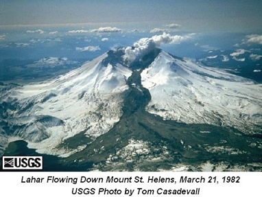
Photo- USGS- http://cimss.ssec.wisc.edu/sage/geology/lesson3/concepts.html